
The San Juan River and its tributaries pass through several historic territories, including those of the Ute and Navajo (Dine) tribes / Image Credit: Environmental Protection Agency
The San Juan River is a 383-mile-long tributary of the Colorado. It begins near Pagosa Springs, Colorado in the San Juan Mountains. It winds through Colorado, New Mexico, and Utah (it shaves northeastern Arizona) before terminating in Glen Canyon, Utah. Along the way, the San Juan is fed by tributaries in each of the Four Corners states.
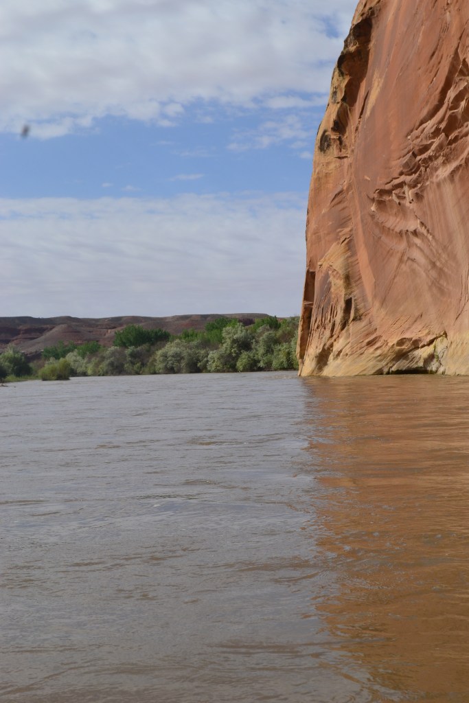
The San Juan River cuts through desert rock and sediment; it allows trees and thick shrubs to grow along its banks (similar to Egypt’s Nile, also in a desert climate) / Image Credit: Kim Meehan

The San Juan’s aquatic obstacles, including logs, have been known to trap/tip over kayaks and rafts / Image Credit: Own Work
TABLE OF CONTENTS:
- Winding and Turning…
- First Explorers of the San Juan (No, Not Europeans)
- A-Maize-ing – Also, Plant Life and Animals
- Too Chicken for Comb Ridge?
- River House
- A Procession in a Palace of Petroglyphs
- Cuckoo for Kokopelli!
- Legendary … Legends (and Survival Tips for One of Them)
Winding and Turning…
The San Juan, as with many areas of the American Southwest, is a product of the Western Interior Seaway (WIS), meaning it was birthed through sediment layers left over by a saltwater body. Cliffs of limestone and sandstone, plus shale beds, run along the river. Some of the formations are more than 300 million years old. The San Juan crafted “goosenecks”, or canyons and valleys resembling the birds’ necks.

Traveling through the “goosenecks”, or canyons and valleys, of the San Juan river provides a look at geological masterpieces – courtesy of World Atlas
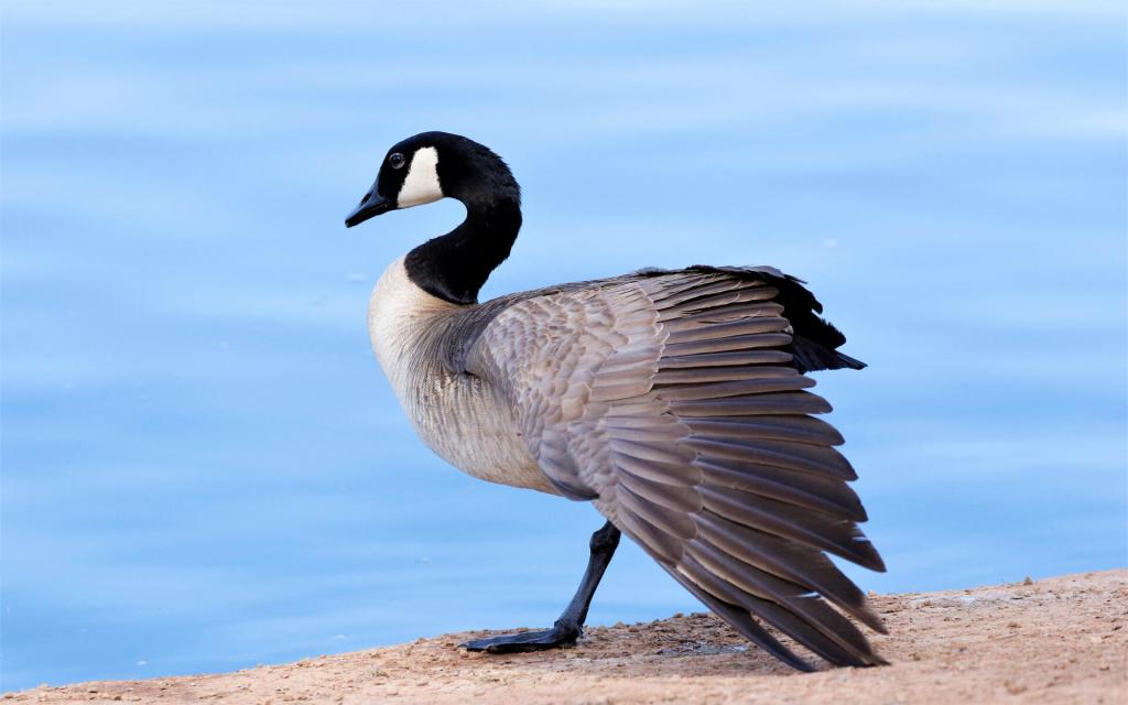
Canadian goose lowers its head, resulting in a twisty, “s” shape to its neck; the “goosenecks” of the San Juan are named after this – courtesy of National Audubon Society
The San Juan, unlike other meandering rivers, twists around deep-carved canyons. Meandering rivers’ low gradients cause their twists and turns; this condition generally doesn’t carve canyons. The San Juan was able to do so since, 15-20 million years ago, its headwaters rose in tandem with the Colorado plateau itself. This increased the river’s gradient, flow velocity, and downcutting rate. The San Juan’s direction was already set, so it resisted natural attempts to change its direction. It dug deeper into the earth, making the formations along it today.
First Explorers of the San Juan (No, Not Europeans)
The first known peoples in the San Juan Mountains were of the Folsom cultures. Their sphere occupied what became Colorado between 7,000-13,000 years ago. Ancestral Puebloans (long known as Anasazi) inhabited the mountains as early as 200 B.C., while the Ute tribe (from which Utah derives its name, as our Navajo (Dine) river guide explained) came in from the north circa 1300 A.D. The Utes’ arrival probably factored into Ancestral Puebloans’ decision to move southward.

Ute lands were vast and subject to decentralized organization; there was no “hub” city or settlement, though some population centers held more influence over certain areas than others; other Native American tribes lived within and around Ute territory – courtesy of Marriott Library Digital Collections
The Ute tribe, though one of the then-most recent in the American Southwest, soon adapted and settled in what are now Colorado, Utah, Wyoming, Nevada, New Mexico, and Arizona (the Navajo, who also arrived late, employed a similar assimilation strategy). This territory is comparable to modern mid-sized nation-states, but it – as with other Native American tribal territories – wasn’t organized as such. The Ute were a loosely-connected confederation of units called bands, each with their own names. The ones which settled along the San Juan river were the Weenuchiu, or Weemeenooch, and Kahpota bands.
John Wesley Powell was one of the first known people of European descent to have been up the San Juan. During a 1869 expedition along the Colorado, Powell and his fellow explorers reached the mouth of the San Juan on July 31. Powell and company, plus a few other explorers after them, provided their own accounts of what happened. These accounts, in conjunction with a U.S. government-promoted-and-sponsored westward push for white Americans, caused the Colorado, the San Juan, and other rivers (plus their tributaries, whenever possible) to be traversed in greater numbers.
A-Maize-ing – Also, Plant Life and Animals
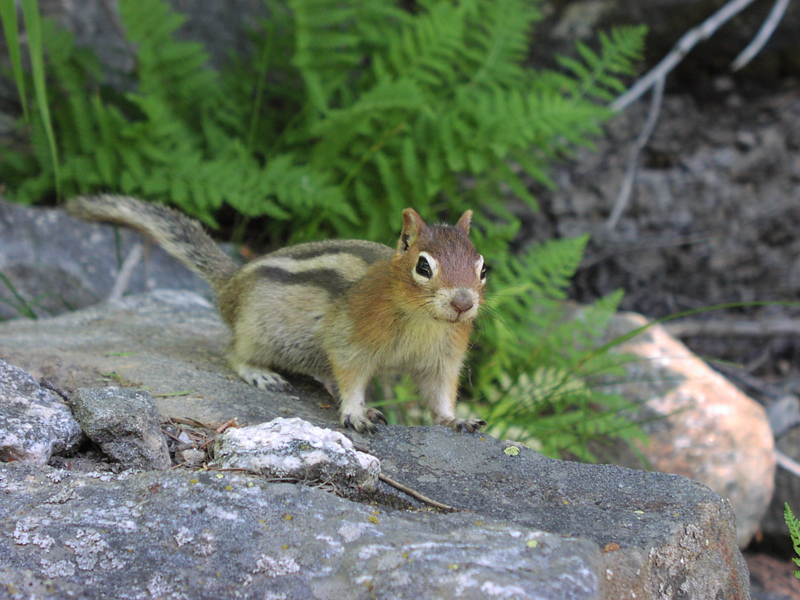
The San Juan Basin (where the San Juan Mountains and San Juan River are located) contains plant species exemplary of the American Southwest, such as Pinyon-Juniper, Sagebrush, Ponderosa Pine, and Douglas Fir. Animal species which benefit from these plants, directly or indirectly, are the Black-tailed Jackrabbit, Golden-mantled Ground Squirrel, and Merriam Kit Fox.

Ponderosa pine is a common sight in the American Southwest – courtesy of Sacramento Tree Foundation
In the San Juan Basin, Native Americans grew crops attuned to the arid lands. The most famous of these crops is maize, a variety of corn. Maize arrived in the American Southwest in two waves. The first variants entered 4,000 years ago, while the second variants entered 2,000 years ago. The corn domestication process involved removal of (to humans) less desirable traits, such as shattering (its seed dispersal system), and evolution of more favorable (to humans) traits, such as drought tolerance, taste, nutritional qualities, and easier processing. It was so important to Native Americans, it has been found at various ruins hundreds of miles apart from each other. In light of its already-widespread consumption, it’s no wonder corn later developed into a U.S. staple.
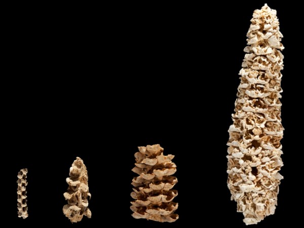
Maize of the American Southwest came in plentiful sizes; the texture and consistency was akin to its forebears in what are today Mexico’s highlands rather than modern corn cob varieties – courtesy of The Archaeological Conservancy
Too Chicken for Comb Ridge?
Comb Ridge runs 80 miles south-north from Kayenta, Arizona to Blanding, Utah. The ridge has a twenty degree angle/slope and is over a mile wide. The name of the ridge is derived from its resemblance to a rooster’s comb, or head top.

Utah section of Comb Ridge – courtesy of USGS

Comb Ridge derives its name from roosters’ comb, or the distinctive fleshy crown on top of their heads – courtesy of The Happy Chicken Coop
Comb Ridge is a monocline, or step-like bend of rock layers in one direction. 65 million years ago, tectonic plates slipped beneath where the ridge is today and created a rugged scar across the land.

Comb Ridge was formed by two tectonic plates colliding; in their wake were bumps, or flatirons, which stand out, and whose resemblance to a rooster comb eventually gave the ridge its name – courtesy of Utah Geological Survey
Humans have been on and around Comb Ridge since the Ice Age. Ancestral Puebloans left their mark with cliff dwellings and desert-traversing roads on or near the ridge (the latter are referred to as “Anasazi roads” and may’ve been part of a broader travel system used to communicate and trade with other Native American locales in the region). Anglo settlers’ most notable contribution to the area was a trail portion used by Mormons. In 1880, the notoriously-perilous Hole-in-the-Rock trek crossed the ridge itself before terminating in Bluff. Some Mormons bypassed this stretch by traveling south along Comb to the San Juan River. There, they built a dugway – referred to as “San Juan Hill” – up the ridge face so as to make this section slightly easier.
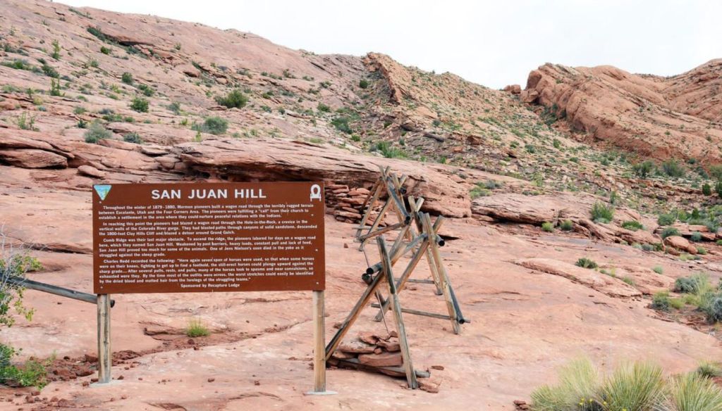
“San Juan Hill” was intended to make westward travel (comparatively) more comfortable for Mormon settlers – courtesy of Deseret News
River House
Arguably the most famous Ancestral Puebloan site at Comb Ridge is the River House Ruin along the San Juan. It is located in a section of Comb Ridge approximately twelve miles southwest of Bluff, Utah. The settlement was inhabited by its Native American builders between 900 A.D. and the late 1200s A.D. Various pictographs, (one and two room) residences, a kiva, and granaries have been left behind.
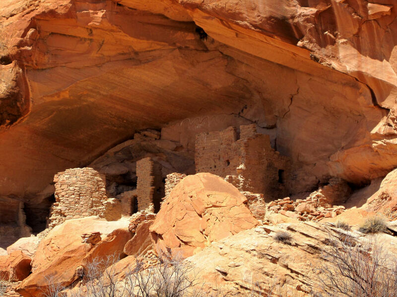
The architectural and functional sophistication of buildings such as those at River House make one ponder what Native Americans could’ve achieved later on if European colonization never happened – courtesy of Climb Utah
A Procession in a Palace of Petroglyphs
Comb Ridge has plethoric petroglyphs. One of the better-known of these is the Procession Panel. Three snaking lines of 179 human-like figures march in single file and converge on a great circle. Deer, bighorn sheep, elk, and geometric shapes are also depicted. The smaller human figures seem to be led by larger ones carrying hooked staffs and wearing headdresses. Archaeologists and anthropologists have guessed these figures are shamans who interacted with the spirit world and its animal assistants.

The Procession Panel (as with other Native American petroglyphs) has the mystique of a time long gone, but, sadly, there has been no solid conclusion as to what it represents – courtesy of Hiking & Walking
We said “guessed” – there’s a reason for this. For all the research which has gone into Comb Ridge’s petroglyphs, their exact meanings to their Ancestral Puebloan creators have been lost to time. Consequently, a significant number of declarations made about this art has been estimated guessing. Even so, these petroglyphs are valuable, since (as far as can be seen) Comb Ridge inhabitants’ culture, clothing, clan symbols, migrations, and supernatural journeys of shamans are depicted.
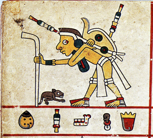
One of the pictographs/petroglyphs you can find along the San Juan/at Comb Ridge is a version of Kokopelli. If the name does not ring a bell, here is what the figure looks like:
Cuckoo for Kokopelli!

One of innumerable variants of the Kokopelli figure – courtesy of Kokopelli Agency
Kokopelli, in U.S. pop culture, is tied to the American Southwest. It’s so broadly known in the nation, chances are you’ll easily find someone from there who recognizes the design, even if they’ve neither heard the name nor understand the meaning behind it.

An etched Kokopelli variant, noticeably lacking vivid coloration and noodle-shaped body – courtesy of DesertUSA

Kokopelli variant near Bluff, Utah – courtesy of Bluff, Utah (Town Website)
Kokopelli, in American Southwest petroglyphs, has shared characteristics such as holding a flute to one side and hair jutting from the head’s peak. Other than this, the petroglyphs vary in size, stature, and even whether it has visible garments. Depending on the legend, Kokopelli is a crop fertility deity, a male trader going from village to village with a sack of goods, an insect, a benign trickster, a rainmaker, and a bringer of new life.
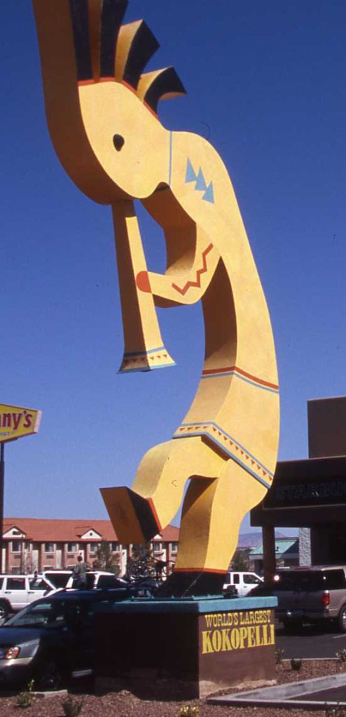
Kokopelli’s been exploited for commercial gain, as it is here in Camp Verde, Arizona – courtesy of Arizona Oddities
Prior to European contact, Kokopelli could be found in the cultures of the Hohokam, Quechcan (not to be confused with the Quechua of South America)/Yuman, and Ancestral Puebloans. The earliest evidence of Kokopelli’s presence is on Hohokam pottery from between 750 A.D. and 850 A.D. This depiction emerged around the time peoples of the American Southwest constructed and populated pueblos, so earlier traces of the character could exist but haven’t been found yet. A theory about Kokopelli says the character may derive from not only blessings, mythical tales, prayers for rain, etc., but pochtecas too. Pochtecas were traders travelling north from Aztec lands, often carrying large bags and potentially blowing flutes to announce their arrival.
Pochtecas of Aztec (central Mexican) regions may’ve inspired Kokopelli; given its heavy ties to American Southwest cultures, though, it’s equally possible Kokopelli was created as a blend of reality and folklore – courtesy of Mexicolore
In any event, post-Hohokam decline, the Hopi and Zuni became the primary (and today more famous) sources for ancient Kokopelli examples. The Hopi and Zuni, along with other tribes, passed Kokopelli’s significance all the way to today’s Puebloans. Kokopelli is significant for non-Native American Americans in the Southwest and beyond, albeit in a different way. It’s associated with the American Southwest generally outside of its original indigenous context, and is, as with other Native American cultural markers, crassly commercialized for advertising and tourism purposes.
Legendary … Legends (and Survival Tips for One of Them)
Hopi, Zuni, Navajo (Dine), and other tribes have their own tales of the San Juan.
Hopi and Zuni legends speak of earlier peoples along the river. One of these is “The Dreamer”, who used a dug-out log from around River House to travel down the river, into the Colorado, and finally into the Grand Canyon.
The Navajo (Dine), who also navigated the river, created their own stories. Our river guide, himself Dine, explained that, in some tales, the river is a sentient being to be traveled along carefully (even jumping in for a brief swim is warned against). If angered, awoken from sleep, or wronged in some other way (even if unintentionally), the being can grab anyone who has fallen overboard/swam in and drag them under, never to be seen again.
Keep in mind, it has been months since our river excursion happened, so we may have gotten some details from our guide’s explanations wrong. Nevertheless, the basic gist is the folklore (as in other parts of the world), in a pre-“modern sciences” era, served as explanations for things which weren’t as easily understood at the time. Our guide revealed the natural force the Navajo (Dine) river tales referred to is what is now known as a whirlpool.

Whirlpool in Japan – courtesy of Japan Guide
A whirlpool is when water moving in two different directions collides and interacts thus: having no ability to travel the same way before impact, the two water flows turn and swirl around each other.
Wherever they’re to be found, and no matter how long they last or how wide an area they cover, it’s NEVER a good idea to treat whirlpools as completely harmless. People, and even small boats, can be sucked in by even the most seemingly-insignificant whirlpools, which can range from a nuisance to only slightly less troublesome than the largest ones (called maelstroms). In certain cases, a smaller whirlpool and a maelstrom can be as just as deadly, no matter how it seems on the water’s surface.
Considering our own kayak tipped over into an already-heavy-volume-and-rushing-current San Juan, our grasping at a log to prevent ourselves from being dragged downstream, and our guide saving us from greater peril (if you’re reading this, shout out to you since we’ll always be thankful for that), it’s a miracle we didn’t hit a whirlpool that day.
If one can’t avoid a whirlpool outright, there are measures to be taken. First and foremost, if there are any signs of whirlpools, it’s best to not enter the water. If no signs were visible, and you so happen to notice a whirlpool at the last minute/a whirlpool formed while you were out … you could be in serious trouble. Of course, that’s where PRE-preparation comes in. Life vests and helmets are needed before entering the water, as they can protect you from the strong currents around whirlpools.
If you’re unlucky enough to enter a whirlpool despite your best efforts, there’s still a chance for survival. Don’t move in the same direction as the water flow. Aim for the outer edge instead of the center. In a boat or kayak, try to prevent them from filling with water. If you’re really lucky, the whirlpool will spit you back out and you can row or swim to safety.
A last aside for this page: Bluff Fort. Located in … Bluff, Utah, the site commemorates the 1880 foundation of the Mormon pioneer town. Bluff Fort contains remnants and reconstructions of original buildings and equipment from the age of westward U.S. expansion, plus Native American residences and artifacts.

Diagram of a Whirlpool product; no reason for this being here, just that we found it when we entered “whirlpool diagram” on Google Search – courtesy of Whirlpool
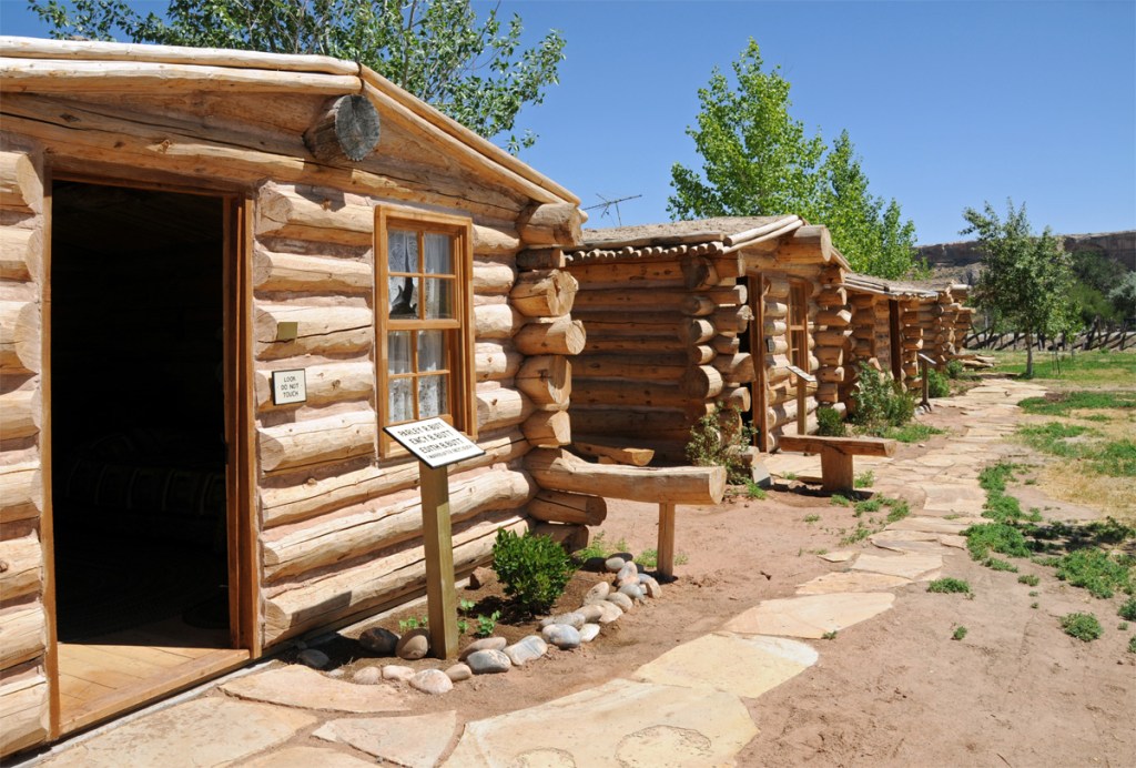
Bluff Fort contains authentic and replica cabins of the type Mormons would’ve used when they reached what is today Bluff, Utah – courtesy of Ensign Peak Foundation
Bibliography
- “San Juan River – near Pagosa Springs”. Uncover Colorado. https://www.uncovercolorado.com/activities/san-juan-river/
- “Desert Varnish”. United States National Park Service. February 25, 2022 (Updated). https://www.nps.gov/articles/desertvarnish.htm
- Robinson, Marshall. “Geosights: The Goosenecks of the San Juan River, San Juan County, Utah”. Utah Geological Survey. https://geology.utah.gov/map-pub/survey-notes/geosights/goosenecks-of-the-san-juan-river/
- “Native American Habitation of the area now known as the San Juan Skyway dates back Thousands and Thousands of Years”. Inns of the San Juan Skyway. https://www.coloradoskyway.com/articles/native-american-habitation-of-the-area-now-known-as-the-san-juan-skyway-dates-back-thousands-and-thousands-of-years/
- Harris, Arthur H., Koster, William J., and Niles, David M. “Ecological Distribution of some vertebrates in the San Juan Basin”. Museum of New Mexico Press. 1963. https://www.utep.edu/leb/pdf/curators/ecologicaldistribution.pdf
- Benson, Larry, Cordell, Linda, Vincent, Kirk, et al. “Ancient maize from Chacoan great houses: Where was it grown?”. PNAS. 16 October 2003. Vol. 100, No. 22. https://www.pnas.org/doi/10.1073/pnas.2135068100
- “Ancient maize followed two paths into the Southwest”. The Archaeological Conservancy. 13 January 2015. https://www.archaeologicalconservancy.org/ancient-maize-followed-two-paths-southwest/
- Podmore, Zak. “More Than a Wilderness: The San Juan’s Rich Human History”. OARS. https://www.oars.com/blog/san-juan-river-human-history/
- “John Wesley Powell’s Exploration of the Colorado River”. USGS. 28 March 2006 (Updated). https://www.nps.gov/parkhistory/online_books/geology/publications/inf/powell/sec7.htm
- McGlothlin, Jess. “The History of River House Ruin (and How to Experience It Today”. RootsRated. 30 November 2018. https://rootsrated.com/stories/the-history-of-river-house-ruin-and-how-to-experience-it-today
- “Comb Ridge”. Bluff, Utah (Town Website). https://bluffutah.org/comb-ridge/
- Matcha. “The Petroglyphs of Comb Ridge”. Visit Utah. https://www.visitutah.com/articles/the-petroglyphs-of-comb-ridge
- Hughes, Art. “Kokopelli: origins, history, and appropriation”. Native America Calling. 5 June 2019. https://www.nativeamericacalling.com/wednesday-june-5-2019-kokopelli-origins-history-and-appropriation/
- Flynn, Brian. “What is the Kokopelli?”. Kokopelli Agency. 31 October 2021. https://kokopelliagency.com/blog/what-is-kokopelli
- Harvey, Ailsa. “Whirlpools: Facts, formation and survival tips”. LiveScience. 11 May 2022. https://www.livescience.com/whirlpools
- “Bluff Fort Historic Site”. Utah’s Canyon Country. https://www.utahscanyoncountry.com/Bluff-Fort-Historic-Site
ancient publeon Casa Riconda Chacoan Great Houses Chaco Culture National Historical Park cliff palace Hugo Pavi isla mujeres Junior Park Ranger program Kivas long house mesa verde Mesa Verde audio tour mug house National Park North Beach petroglyphs Petroglyph trail Pueblo Bonito Pueblo del Arroyo Recreation.gov reviews Square House Tower Supernova tour ultramar Una Vida Wetherill mesa whale shark snorkel
