NOTICE: THIS IS A HIGH ALTITUDE ATTRACTION. PEOPLE USED TO LIVING IN LOWLAND AREAS SHOULD BE AWARE OF AND PREPARED FOR POTENTIAL BREATHING AND EXHAUSTION ISSUES.

“Should you shield the canyons from the windstorms, you would never see the beauty of their carvings”
— Elizabeth Kubler-Ross
- Bryce Canyon National Park- https://www.nps.gov/brca/index.htm
- Hours:
- Fees:
- Entrance Fees- purchase: https://www.recreation.gov/
- Getting Here:
- Avoid Congestion- use the FREE park shuttle- https://www.brycecanyonshuttle.com/ for up to date info!
- Bryce Canyon Amphitheater Parking Lot Capacity
- Demographics:
- Leave No Trace:
- What To Pack In Your Day Backpack
- Bryce Canyon Visitor Guide: https://www.nps.gov/brca/planyourvisit/upload/Bryce_Canyon_Visitor_Guide_508.pdf
- Hike The Hoodoos Program (Scavenger Hunt)
- Let’s Go Tour
- Famous Hoodoos To Find:
- Easy Hikes:
- Moderate Hiking
- Strenuous Hikes
Bryce Canyon National Park- https://www.nps.gov/brca/index.htm
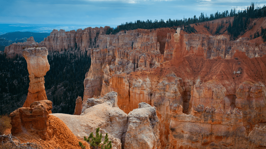
Bryce Amphitheater has the highest concentration of hoodoos (irregular columns) anywhere on Earth. The parks was established on June 8, 1923. It covers 35,835 acres (14,501 hectares) with its lowest elevation of Lowest Elevation: 6,620 feet (2018 meters) at Yellow Creek and highest elevation of 9,115 feet (2778 meters) at Rainbow point.
Hours:
Open 24 hours/ 7 days a week.
Visitor Center- open 8-8 Summer: May 7- October 1,
8-6 Fall: October 2nd- November
8-4:30 Winter: November 7-March 25
8-6 Spring: March 26- May 6
Fees:
Tickets can be purchased online prior to visiting- be sure and download a copy of your ticket as wifi service may be absent or sporadic!
Entrance Fees- purchase: https://www.recreation.gov/
| Entrance Fees (Valid for 7 consecutive days) | Fee | |
| Private Vehicle Admits one private, non-commercial vehicle (15 passenger capacity or less) and all occupants. | $35 | |
| Motorcycle | $30 per motorcycle | |
| Per Person (Bicycle, Walk-in) Admits one individual with no car to the monument – typically used for bicyclists and walk-ins. Youth 15 and under are admitted free. | $20 | |
| Bryce Canyon Annual Pass | ||
| Bryce Canyon National Park Annual Pass Valid for entry into Bryce Canyon National Park for 12 months from purchase. See information on annual and lifetime passes below. | $70 |
| Other Annual Passes | |
| America the Beautiful Series Passes (Good at most Federal Fee Areas) Available for purchase at the park. Annual, Military, Senior, and Access passes can also be bought online. For more information on these passes visit the National Parks and Federal Recreation Lands Pass Program. | Varies |
| Annual 4th Grade Pass (good at most Federal Fee areas) Available to U.S. 4th graders with a valid Every Kid in the Outdoors paper voucher. See information on annual and lifetime passes below. | Free |
| Passes for Veterans and Gold Star Families Beginning on Veterans Day, November 11, 2020, Gold Star Families and U.S. military veterans receive free access to more than 2,000 federal recreation areas, including national parks, wildlife refuges and forests. The free access program is a way to thank America’s veterans and Gold Star families for their support of our country and to encourage them to explore recreational opportunities on their public lands and waters. For more information on the program and how to obtain free entrance, please visit https://www.nps.gov/planyourvisit/veterans-and-gold-star-families-free-access.htm. | Free |
| Lifetime Passes (U.S. Citizens / Permanent Residents) | |
| Interagency Senior (Age 62+) Available for purchase at the park. For more information on these passes visit the National Parks and Federal Recreation Lands Pass Program. | $80 |
| Interagency Access (Permanently Disabled) Available at the park. For more information on these passes visit the National Parks and Federal Recreation Lands Pass Program. | Free |
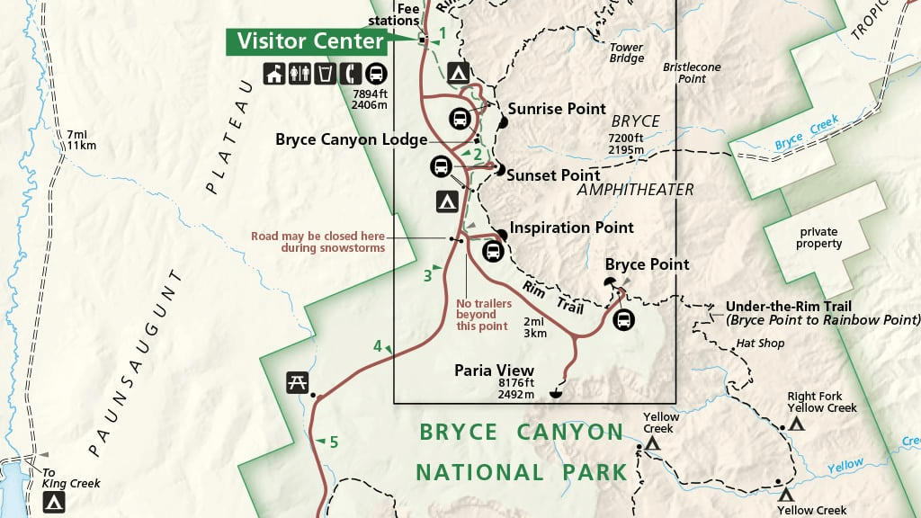
Getting Here:
Physical Address:
Bryce Canyon National Park
UT-63
Bryce, Utah 84764
Official GPS Coordinates at the Visitor Center:
Latitude: N 37° 38′ 24″ / Longitude: W 112° 10′ 12″
Latitude: 37.6 / Longitude: -112.1
Elevation: 7,894 feet/2,406 meters
Plane:
The closest major airports are in Las Vegas (LAS), Nevada and Salt Lake City (SLC), Utah, each approximately 270 miles from the park. There are smaller airports in Cedar City (CDC), Utah (80 miles) and St. George (SGU), Utah (125 miles).
Avoid Congestion- use the FREE park shuttle- https://www.brycecanyonshuttle.com/ for up to date info!
- The shuttle is free with park admission: Your park entrance receipt or annual pass allows you and the occupants of your vehicle unlimited shuttle access.
- Buses typically arrive at each stop every 15 minutes, but with the new Bryce Canyon Shuttle Tracker you can time your next ride to the minute.
- The best place to board the shuttle is before you enter the park, at the Shuttle Station in Bryce Canyon City (Stop 1), or at the Visitor Center (Stop 6).
- The best place to park your car is at the Shuttle Station in Bryce Canyon City or the Additional Parking lot across from the Visitor Center.
- All buses are wheelchair accessible and can accomodate 2 bicycles on a front rack.
- Masks are currently optional for all shuttle riders.
- Pets are not permitted on the shuttle.
- There is no shuttle access to the Southern Scenic Drive (miles 4-18)
Bryce Canyon Amphitheater Parking Lot Capacity
Bryce Point
- 49 total spaces
- 3 oversized spaces
- 37.603990215164075, -112.15666055747494
Fairyland Point
- 20 total spaces
- 3 oversized spaces
- 37.64956305831303, -112.14783232158946
Inspiration Point
- 36 total spaces
- 7 oversized spaces
- 37.61511208257475, -112.17066791443324
Paria Point- CLOSED TO ALL OVERSIZED VEHICLES
- 21 total spaces
- 0 oversized spaces
- 37.59694173844027, -112.16948514726312
Sunrise Point
- 113 total spaces
- 3 oversized spaces
- 37.631265873960075, -112.16447969793154
Sunset Point
- 115 total spaces
- 7 oversized spaces
- 37.62374109286889, -112.16706733464082
Demographics:
- Total Area: 35,835 acres (14,501 hectares)
- Lowest Elevation: 6,620 feet (2018 meters) Yellow Creek
- Highest Elevation: 9,115 feet (2778 meters) Rainbow Point
- Elevation at Visitor Center: 7,894 feet (2,406 meters)
- Elevation at Sunset Point: 8,000 feet (2,438 meters)
Leave No Trace:


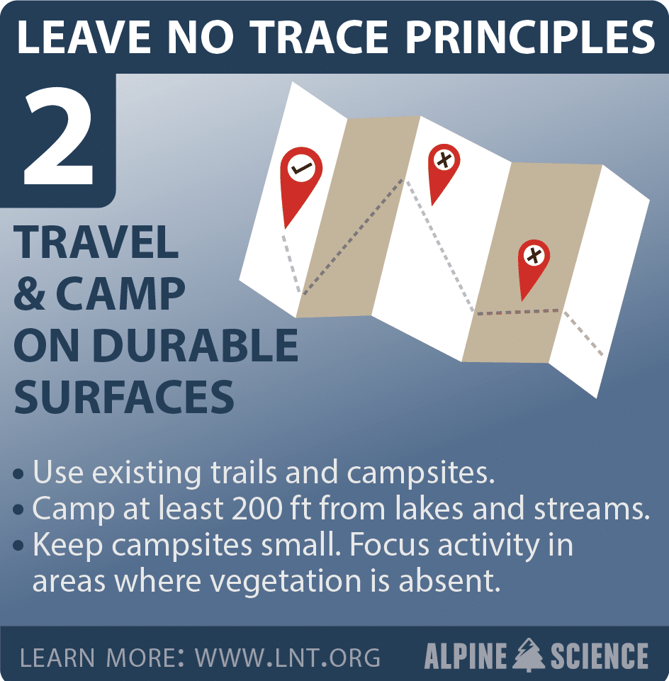


What To Pack In Your Day Backpack
Navigation: map, compass, altimeter, GPS device, personal locator beacon (PLB) or satellite messenger
- Headlamp: plus extra batteries
- Sun protection: sunglasses, sun-protective clothes and sunscreen
- First aid including foot care and insect repellent
- Knife plus a gear repair kit
- Fire matches, lighter, tinder and/or stove
- Shelter carried at all times (can be a light emergency bivy)
- Extra food Beyond the minimum expectation
- Extra water Beyond the minimum expectation- recommended minimum is 2 L/person
- Extra clothes Beyond the minimum expectation
Bryce Canyon Visitor Guide: https://www.nps.gov/brca/planyourvisit/upload/Bryce_Canyon_Visitor_Guide_508.pdf
Hike The Hoodoos Program (Scavenger Hunt)
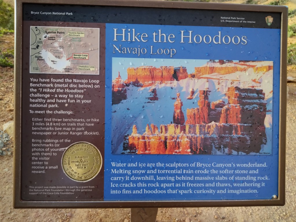
“I Hiked the Hoodoos!” program is not just hiking, it’s also a scavenger hunt with a special reward!
- In order to qualify for the reward, hike a minimum of 3.0 miles,
or find at least 3 benchmarks and complete steps 2 through 4
below. - Each individual must have either a pencil rubbing of the
benchmark (see Jr. Ranger Book) or a”selfie”with the benchmark. - Only special “I Hiked the Hoodoos” benchmarks qualify for the
reward. USGS benchmarks found at various locations within the
park do not qualify. - Rewards are available at the Visitor Center, so bring your
photos or pencil rubbings to the front desk!
Benchmark Distance
Mossy Cave- 0.8 mi
Rim Trail/ Fairyland- 2.5 mi
Tower Bridge- 3.0 mi
Queen’s Garden- 1.8mi
Navajo Loop- 1.3 mi
PeekaBoo Loop-2.4 mi
Wall of Windows- 1.6 mi
Sheep Creek- 4.0 mi
Bristlecone Loop- 1.0 mi
Let’s Go Tour
Famous Hoodoos To Find:
Thor’s Hammer:

Go to Sunset point -walk to the Southeastern corner of the paved walkway that follows the rim. There is a short paved trail (Wall Street Trail) that will take you right along side Thor’s Hammer… only about 5 minutes or so).
The Hunter and The Rabbit– located at Agua Canyon- Mile 13.5 of the 18 mile Scenic Southern Drive
Queen Victoria– located in the Queen’s Garden

Easy Hikes:
Mossy Cave Trail-
Mossy Cave trail is one of the lowest elevation hikes in the park as well as one of the only hikes that begins with a climb and ends with a descent. It is also the northernmost hike in the park, located just off of SR 12 as it winds its way through the park boundary.
- Trailhead: Northern end of the park, 4 miles east on Hwy 12
- Parking: At trailhead (check when parking lots are busiest). Oversized vehicles permitted.
- Distance: 0.8 miles (1.3 km)
- Approximate Time: 1 hour
- Elevation Gain: 150 feet (46 meters)
- Difficulty: Easy (elevation gain of 200 feet or less, shorter length)
- Services: Accessible restrooms available at the trailhead.
- Shuttle Service: None. Private options may be available.
- Pets are not allowed on this trail. Service animals are allowed in national parks. What is a service animal?
- Delicate rocks and sensitive plants exist throughout this area. Please stay on the main trail and respect all posted signs.
- While visitors are permitted within the water, we ask that they enter and exit at bridge crossings to reduce social trails elsewhere.
- Mossy Cave is a fee area, like the rest of the park. Keep your park pass or proof of admission with your vehicle for rangers to inspect.
Sunset Point to Sunrise Point Hike
- Trailhead: Sunset Point or Sunrise Point
- Parking: Available at both Sunrise and Sunset Points (check when parking lots are busiest). Oversized vehicles are not permitted in these parking areas when the shuttle is in operation.
- Distance: 1.0 mile (1.6 km) (half-mile one-way)
- Approximate Time: 1 hour
- Elevation Gain: 40 feet (12 meters)
- Difficulty: Easy (elevation gain of 200 feet or less, shorter length)
- Shuttle Service: Yes.
- Services: Accessible restrooms available at Sunset Point (year-round) and at the General Store near Sunrise Point (seasonally). Water-fill stations available at Sunset Point (seasonally), the Sunset Point restroom (year-round), and the General Store (seasonally).
- Pets are allowed on paved surfaces.
The Rim Trail
- Trailhead: Bryce, Inspiration, Sunset, Sunrise, or Fairyland Point.
- Parking: Available at each trailhead above (check when parking lots are busiest). With the exception of Fairyland Point, oversized vehicles are not permitted in these parking areas when the shuttle is in operation.
- Distance: 1.0 mile to 11.0 miles (1.6 km to 17.7 km) depending on how far you choose to walk.
- Bryce to Inspiration: 1.5 miles (2.4 km)
- Inspiration to Sunset: 0.7 miles (1.1 km)
- Sunset to Sunrise: 0.5 miles (0.8 km)
- Sunrise to Fairyland 2.8 miles (4.5 km)
- Approximate Time: 1 hour to 7.5 hours
- Elevation Gain: 719 feet (219 meters)
- Difficulty: Easy to Moderate
- Services: Accessible restrooms available at Sunset Point (year-round) and available at the General Store near Sunrise Point (seasonally). Water-fill stations available at Sunset Point (seasonally), the Sunset Point restroom (year-round), and the General Store (seasonally).
- Shuttle Service: Yes. Available at Bryce, Inspiration, Sunset, and Sunrise Points. Fairyland does not have shuttle service.
- In winter, the 1.5 mile (2.4 km) section of the Rim Trail from Bryce Point to Inspiration Point is regularly closed.
Bristlecone Loop Trail
- Trailhead: Rainbow Point or Yovimpa Point
- Parking: At trailhead (check when parking lots are busiest). Oversized vehicles permitted.
- Distance: 1.0 mile (1.6 km)
- Approximate Time: 1 hour
- Elevation Gain: 200 feet (61 meters)
- Difficulty: Easy (elevation gain of 200 feet or less, shorter length)
- Services: Accessible restrooms available (seasonally).
- Shuttle Service: None. Private options may be available.
- This trail may be inaccessible during mid-winter due to snow depths ranging from 2-15 ft. (.7-5 m)
- Pets are not allowed on this trail. Service animals are allowed in national parks. What is a service animal?
This forest is dominated by Blue Spruce, Douglas Fir, and White Fir, making this good habitat for grouse, woodpeckers, owls, and a variety of squirrels and chipmunks. Here you are also sure to see Ravens and Steller’s Jays.
Moderate Hiking
Queen’s Garden Trail is the least difficult of the trails descending from the rim into the Bryce Canyon Amphitheater. Hike this out-and-back trail to the Queen Victoria hoodoo at the end of a short spur trail and experience the splendor of hiking amongst the hoodoos.
- Trailhead: Sunrise Point
- Parking: Available at Sunrise Point (check when parking lots are busiest). Oversized vehicles are not permitted in this parking area when the shuttle is in operation.
- Distance: 1.8 miles (2.9 km) roundtrip
- Approximate Time: 1-2 hours
- Elevation Gain: 450 feet (137 meters)
- Difficulty: Moderate (less than 1000 feet elevation gain, moderate length)
- Services: Accessible restrooms and a water-fill station are available at the General Store near Sunrise Point (seasonally).
- Shuttle Service: Yes.
This trail is commonly combined with the Navajo Loop to create a 2.9 mile round trip trail where you can descend Queen’s Garden at Sunrise Point and ascend Navajo Loop to Sunset Point. Complete the loop using the Sunset to Sunrise section of the Rim Trail.
Navajo Loop Trail begins and ends at Sunset Point. Its switchbacks wind between narrow walls of colorful limestone with views of towering Douglas-fir trees and the park’s most famous hoodoo: Thor’s hammer. The loop has two sides: Two Bridges and Wall Street. The Two Bridges side is open year-round, however, the Wall Street side is closed during the winter months. During this time Two-Bridges can be hiked as an out-and-back trail or combined with other trails.
- Trailhead: Sunset Point
- Parking: At trailhead (check when parking lots are busiest). Oversized vehicles are not permitted in these parking areas when the shuttle is in operation.
- Distance: 1.3 mile (2.1 km)
- Approximate Time: 1-2 hour
- Elevation Gain: 515 feet (157 meters)
- Difficulty: Moderate (less than 1000 feet elevation gain, moderate length)
- Services: Accessible restrooms available at Sunset Point (year-round). Water-fill stations available at Sunset Point (seasonally) and the Sunset Point restroom (year-round).
- Shuttle Service: Yes.
- Only a loop in summer. During this time, we recommend hiking in a counter-clockwise direction. During winter months, Two Bridges can be hiked as an out-and-back trail or combined with other trails.
- Pets are not allowed on this trail. Service animals are allowed in national parks. What is a service animal?
This trail is commonly combined with Queen’s Garden to create a 2.9 mile round trip trail where you can descend Queen’s Garden at Sunrise Point and ascend Navajo Loop to Sunset Point. Complete the loop using the Sunset to Sunrise section of the Rim Trail.
The Queen’s/Navajo Combination Loop combines the open views and unique hoodoos of the Queen’s Garden Trail with the iconic switchbacks and towering canyon walls of the Navajo Loop Trail. Descend Queen’s Garden at Sunrise Point, ascend the Navajo Loop to Sunset Point, and then complete the loop back to Sunrise Point via the Rim Trail, enjoying views into the Bryce Canyon Amphitheater below.
- Trailhead: Sunrise or Sunset Point
- Parking: Available at both Sunrise and Sunset Points (check when parking lots are busiest). Oversized vehicles are not permitted in these parking areas when the shuttle is in operation.
- Distance: 2.9 miles (4.6 km)
- Approximate Time: 2-3 hours
- Elevation Gain: 625 feet (191 meters)
- Difficulty: Moderate (less than 1000 feet elevation gain, moderate length)
- Services: Accessible restrooms available at Sunset Point (year-round) and available at the General Store near Sunrise Point (seasonally). Water-fill stations available at Sunset Point (seasonally), the Sunset Point restroom (year-round), and the General Store (seasonally).
- Shuttle Service: Yes.
- Use the Two Bridges side of the Navajo Loop in winter when Wall Street is closed. We recommend hiking this loop in a clockwise direction.
Swamp Canyon appears relatively small and sheltered from the overlook, allowing the viewer to develop a more intimate connection with the landscape than some of the grander viewpoints in the park. The Swamp Canyon Loop, which starts at the viewpoint, is more rugged than the Bryce Amphitheater trails, taking hikers into a more forested backcountry hike. There is less signage on this hike and hikers are encouraged to carry a map.
- Trailhead: Swamp Canyon Viewpoint (Mile 6 on the Southern Scenic Drive)
- Parking: At Swamp Canyon Viewpoint (check when parking lots are busiest). Oversized vehicles permitted.
- Distance: 4.0 mile (6.4 km)
- Approximate Time: 3-4 hours
- Elevation Gain: 800 feet (244 meters)
- Difficulty: Moderate (less than 1000 feet elevation gain, moderate length)
- Services: None.
- Shuttle Service: None. Private options may be available.
- This trail may be inaccessible during mid-winter due to snow depths ranging from 2-15 ft. (.7-5 m)
Tower Bridge hike consists of the southern portion of the Fairyland Loop trail. This is an out-and-back trail that descends to a shady 1/4-mile spur trail leading to the Tower Bridge hoodoo. From there, hikers can return the way they came or continue to hike the entirety of the Fairyland Loop Trail.
- Trailhead: North of Sunrise Point
- Parking: Available at Sunrise Point (check when parking lots are busiest). Oversized vehicles are not permitted in this parking area when the shuttle is in operation.
- Distance: 3.0 miles (4.8 km) roundtrip
- Approximate Time: 2-3 hours
- Elevation Gain: 760 feet (232 meters)
- Difficulty: Moderate (less than 1000 feet elevation gain, moderate length)
- Services: Accessible restrooms and water-fill station available at the General Store near Sunrise Point (seasonally).
- Shuttle Service: Yes.
Strenuous Hikes
Hat Shop trail descends from Bryce Point into the backcountry using the Under-the-Rim trail, offering views of the colorful cliffs of the Grand Staircase. This strenuous out-and-back hike leads down 1,380 feet (421 meters) over two-miles to a cluster of balanced-rock hoodoos before hikers turn around to return to Bryce Point. These narrow, orange pinnacles wear “hats” of large gray boulders, giving them a distinct appearance compared to hoodoos seen in the Bryce Amphitheater to the north.
- Trailhead: Bryce Point
- Parking: At Bryce Point; oversized vehicles are not permitted in this parking area when the shuttle is in operation.
- Distance: 4.0 miles (6.4 km)
- Approximate Time: 3-4 hours
- Elevation Gain: 1,380 feet (421 meters)
- Difficulty: Strenuous (rapid elevation gain, longer length)
- Services: None.
- Shuttle Service: Yes.
- During winter, the Hat Shop trail is not advised unless you are very well prepared for ice, deep snow, and other winter conditions.
The Fairyland Loop is a quiet 8 mile hike that combines hiking along the plateau rim near Boat Mesa with a hike in the canyon with long views of the Bryce Amphitheater surrounded by unique hoodoos. You can start this hike at Fairyland Point or on the rim trail north of Sunrise Point at the Tower Bridge trailhead. We recommend hiking in a counter-clockwise direction. There is no shuttle pick-up at Fairyland Point, so you will need to hike to your starting point to complete the loop.
- Trailhead: Fairyland Point or north of Sunrise Point at the Tower Bridge trailhead.
- Parking: At Fairyland Point (oversized vehicles permitted) or at Sunrise Point (oversized vehicles are not permitted in this parking area when the shuttle is in operation.) Check when parking lots are busiest.
- Distance: 8.0 mile (12.9 km)
- Approximate Time: 4-5 hours
- Elevation Gain: 1900 feet (579 meters)
- Difficulty: Strenuous (rapid elevation gain, longer length)
- Services: Accessible restrooms available at the General Store near Sunrise Point (seasonally). Water-fill stations available at the General Store (seasonally). No services at Fairyland Point.
- Shuttle Service: Yes at Sunrise Point, None at Fairyland Point. Private options may be available.
- Pets are not allowed on this trail. Service animals are allowed in national parks. What is a service animal?
- This trail may be inaccessible during mid-winter due to snow depths ranging from 2-15 ft. (.7-5 m)
The Peekaboo Loop descends 670 feet (204 meters) from Bryce Point to this hoodoo-filled loop trail before ascending back up to Bryce Point. In summer months, hikers will encounter horses/mules on this trail. We recommend hiking this trail in a clockwise direction.
- Trailhead: Bryce Point
- Parking: At trailhead (check when parking lots are busiest). Oversized vehicles are not permitted in this parking area when the shuttle is in operation.
- Distance: 5.5 miles (8.9 km)
- Approximate Time: 3-4 hours
- Elevation Gain: 1560 feet (474 meters)
- Difficulty: Strenuous (rapid elevation gain, longer length)
- Services: Pit toilets on the west side of Peekaboo Loop (summer only)
- Shuttle Service: Yes.
- This trail may be inaccessible during mid-winter due to snow depths ranging from 2-15 ft. (.7-5 m)
The Bryce Amphitheater Traverse is a one-way hike combining the Peekaboo Loop with the Queen’s Garden trail. Hikers descend from Bryce Point, turning left (clockwise) on Peekaboo Loop and then connecting to the Queen’s Garden trail to ascend to Sunrise Point.
- Trailhead: Bryce Point
- Parking: At trailhead (check when parking lots are busiest). Oversized vehicles are not permitted in this parking area when the shuttle is in operation.
- Distance: 4.7 miles (7.6 km)
- Approximate Time: 3-4 hours
- Elevation Gain: 1145 feet (349 meters)
- Difficulty: Strenuous (rapid elevation gain, longer length)
- Services: Pit toilets on the west side of Peekaboo Loop (summer only)
- Shuttle Service: Yes.
- This trail may be inaccessible during mid-winter due to snow depths ranging from 2-15 ft. (.7-5 m)


