NOTICE: THIS IS A HIGH ALTITUDE ATTRACTION. PEOPLE USED TO LIVING IN LOWLAND AREAS SHOULD BE AWARE OF AND PREPARED FOR POTENTIAL BREATHING AND EXHAUSTION ISSUES.

“Capitol Reed is filled with geology that takes shape, color, and dimension to a level beyond comprehension.”
― Stefanie Payne, A Year in the National Parks: The Greatest American Road Trip
- Need To Know:
- Be Prepared:
- Capitol Reef National Park- Map
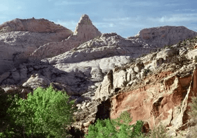
- Geology of Capitol Reef
- Let’s Go Tour:
- Cathedral Valley- HIGH CLEARANCE VEHICLE RECOMMENDED
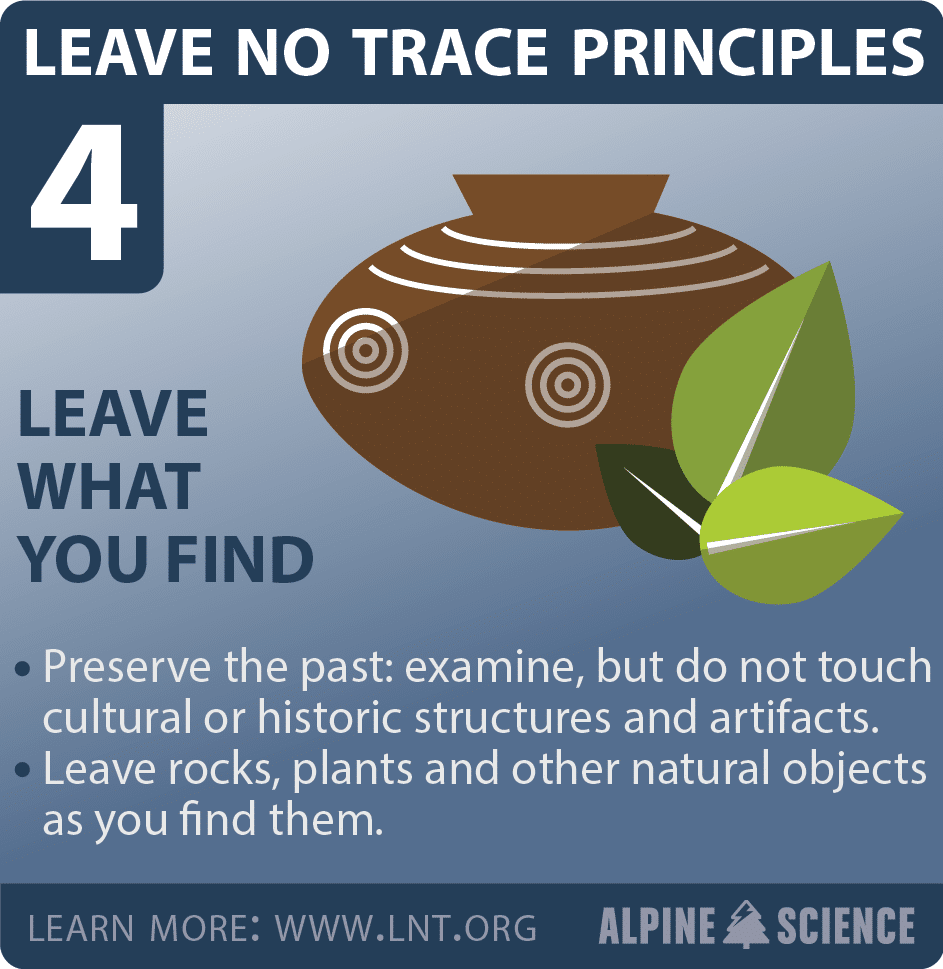
- Fruita Historical District
- Scenic Drive
- https://www.nps.gov/care/planyourvisit/scenicdrive.htm
- Scenic Drive Stops: geological detail- click above link
- Let’s Go Hiking:
- What to pack in my day pack?
- TRAIL DIFFICULTY RATINGS:
- Trails
Need To Know:
Website: https://www.nps.gov/care/index.htm
Address: 52 West Headquarters Drive, Torrey, UT 84775
From I-70: Take exit 149, then take UT-24 west toward Hanksville; continue for 43.8 miles (70.5 km). Turn right to continue on UT-24 west and continue for 37.3 miles (60 km). From I-15: take exit 188 then US-50 east toward Scipio. Left on UT-50; continuing 0.7 miles (1.1 km). Turn right onto US-50 east; continue for 24.4 miles (39.3 km). Turn right onto UT-260 south and continue 4.2 miles (6.8 km), then right on UT-24 for 71.3 miles. UT-12: North on highway 12 to Torrey, UT. Right onto UT-24.
Opening Hours: 24/7- Visitor Centers close for most Federal holidays. Generally open 9-4:30 with extended hours in the summer
Admission: currently a private vehicle is $20. Covered by the America’s Beautiful Pass.


Be Prepared:
Junior Ranger Book, Maps, Brochures, Wildlife Checklists and so much more can be found here https://www.nps.gov/care/planyourvisit/brochures.htm
Capitol Reef National Park- Map


Geology of Capitol Reef

Let’s Go Tour:
Cathedral Valley- HIGH CLEARANCE VEHICLE RECOMMENDED
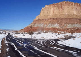
Road Conditions and Weather can be checked at the Visitor Center of by calling 435-425-3791. Press #1 for information, and then #4 for current road conditions. For weather conditions press #3.
If you have problems, help may not arrive for hours or even days, depending on the time of year. Carry plenty of water, food, gas, adequate clothing, a shovel, and emergency supplies. No potable water is available in Cathedral Valley, Cell phone coverage is nonexistent to sporadic. A primitive campsite with pit toilet is in the area.
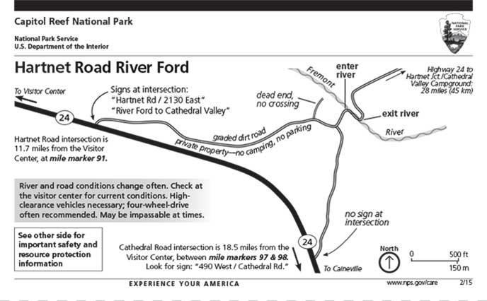
The full River Ford Map and Information can be downloaded and printed here: https://www.nps.gov/care/planyourvisit/upload/river-ford-Mar-20.pdf
Hartnet Road
The drive from Highway 24 to the junction with Cathedral Road affords expansive views of the Blue Flats and the South Desert. The northern end of the loop nears Thousand Lake Mountain, and the geology and topography change greatly with the subsequent gain in elevation.
Distances from Highway 24 starting on the Hartnet Road (traveling clockwise)
- Hwy 24 junction to Lower South Desert Overlook…………………………………………15.2 miles (24.5 km)
- Hwy 24 junction to Upper South Desert Overlook…………………………………………27.2 miles (43.7 km)
- Hwy 24 junction to Cathedral Road Junction………………………………………………..27.8 miles (44.7 km)
- Hwy 24 junction to Cathedral Valley Campground…………………………………………28.1 miles (45.2 km)
- Hwy 24 junction back to Hwy 24 via Cathedral Rd………………………………………..57.6 miles (92.7 km)
Cathedral Road
Massive monoliths, Temple of the Sun and Temple of the Moon, rise from the desert floor along the Cathedral Road. Further north in Upper Cathedral Valley, columns of spire-like formations dominate the landscape.
Distances from Highway 24 starting on the Cathedral Road (traveling counterclockwise)
- Hwy 24 junction to Temple of the Moon………………………………………………………17.1 miles (27.5 km)
- Hwy 24 junction to Oil Well Bench Road junction………………………………………….20.5 miles (33.0 km)
- Hwy 24 junction to Gypsum Sinkhole………………………………………………………….25.6 miles (41.1 km)
- Hwy 24 junction to Baker Ranch Road junction……………………………………………24.6 miles (39.6 km)
- Hwy 24 junction to Cathedrals trailhead………………………………………………………27.4 miles (44.1 km)
- Hwy 24 junction to Morrell Cabin trailhead…………………………………………………..28.1 miles (45.2 km)
- Hwy 24 junction to Hartnet Junction……………………………………………………………29.9 miles (48.0 km)
- Hwy 24 junction back to Hwy 24 via Hartnet Rd…………………………………………..57.6 miles (92.7 miles)
Fruita Historical District

Fremont Petroglyphs– located 1.5 miles from the Visitor’s Center on Rte 24. A shaded path takes you along the walls where the petroglyphs are located. Excellent markings.
Fruita Orchard– begins one mile after Visitor’s Center- home to 3,000 fruit,berry and nut trees. When picking is in season- signs are posted along the road allowing you to pick fresh fruit.
Gifford’s Homestead– located near the orchards is the place to purchase fresh, home made pies (individual or large). Pies offered reflect the fruits available at that time. This is the ONLY food available within the park (other than prepackaged snacks at the Visitor Center). You can also purchase water to drink. It is the thing to do- grab a pie and enjoy it in the provided picnic area or in the meadows.
Merlin Smith Implement Shed- work off that pie with a short stroll to the Merlin Smith Shed to check out the black smithing tools and trade.
Ripple Rock Nature Center- open in the Summer (Memorial Day-Labor Day) hosts fun activities. There is fossil digging, scavenger hunts, geology education and so much more!
Schoolhouse- the one room schoolhouse is located on Rt 24 and is one of the few remaining pioneer buildings still standing.


Scenic Drive
https://www.nps.gov/care/planyourvisit/scenicdrive.htm
The Scenic Drive, Grand Wash, and Capitol Gorge roads can be closed due to snow, ice, mud, and flash floods. Check at the visitor center, or call 435-425-3791, for possible road closures. Press #1 for information, and then #4 for current road conditions. For weather conditions press #3. You are responsible for your own safety
Admission: The entrance fee for Capitol Reef is collected at the Scenic Drive guard booth.
Scenic Drive Stops: geological detail- click above link
Stop 1: 225 million year old rock is the Moenkopi Formation. The Moenkopi, more than 950 feet (290 m) thick in places, was laid down in a moist, tropical climate

Stop 2: Waterpocket Fold

Stop 3: Grand Wash spur- Grand Wash is a narrow, steep-walled canyon subject to dangerous flash floods that often arrive with little warning. Avoid canyons and washes when storms threaten. A short drive leads to foot trails lead into the narrowest part of the canyon and up to Cassidy Arch on the canyon’s north wall. The arch was named for turn of the century outlaw Butch Cassidy, who is thought to have hidden occasionally in Grand Wash.
Stop 4: Wingate Sandstone

Stop 5: Vegetation – a chance to see the Capitol Reef Vegetation- click above link to get more info.
Stop 6: Road now passes through a deeper, older section of the Moenicki Formation
Stop 7: Slick Rock Divide- drainages to either side empty water into the basin (Grand Wash to the North and Capitol Gorge to the South)
Stop 8: Old gated mine tunnels at the mouth of Grand Wash penetrate the Shinarump which contains uranium ore- occasionally used in pioneer medicines.
Stop 9: Capitol Gorge spur road- shows the erosion processes.
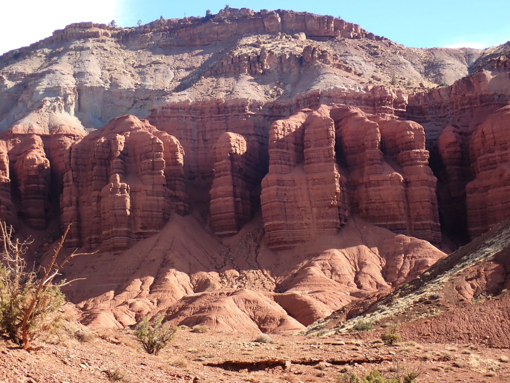
Stop 10: The Navajo Formation, over 1,400 feet (427 m) thick in places, caps the upper reaches of Capitol Gorge. Its white, rounded domes, reminiscent of the nation’s capitol building, inspired part of the name for Capitol Reef.
Stop 11: Stroll into the Capitol Gorge to find the Pioneer Registry.


Let’s Go Hiking:
What to pack in my day pack?

Hiking requires serious preparation to avoid mishaps and other undesirable outcomes. The Boy Scout Motto “Be Prepared” ensures you are ready for any possibility. So here’s what needs to be in your pack!
Navigation Supplies: maps, compass are a must. Helpful are GPS, a personal locator beacon or satellite messenger
Headlamps/Flashlights– plus extra batteries
Sun Protection– sunglasses, sunscreen, sun protective clothing
First Aid– make sure you have moleskin or similar for footcare and insect repellant! Hiking specific kits are a good investment.
Knife– gear repair kit
Fire- matches or lighter
Shelter- emergency heat blankets (foil)
Extra Food– pack more than you will need
Extra Water– pack more than you will need. Consider purchasing a Filtration Straw that can be used if safe drinking water is not available.
Extra Clothing- socks, a jacket (layers work best), rain poncho, etc.
Hiking stores such as REI https://www.rei.com/learn/expert-advice/ten-essentials.html, L.L. Bean https://www.llbean.com/ are just a few stores that can assist you.
TRAIL DIFFICULTY RATINGS:
Easy: uneven ground, but fairly level.
Moderate: a mix of steep grades and level sections.
Strenuous: steep grades, uneven terrain and long, steady climbs.
Starting elevation for many trails in Capitol Reef is around 5,000 feet (1524 meters), which can make even “easy” trails challenging for people visiting from lower elevations.
Trails
| Trail | One-Way Distance | Elevation Change | Difficulty | Description |
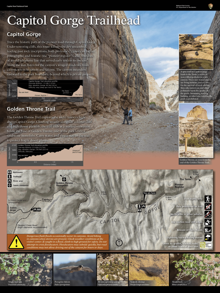
| Capitol Gorge | 1.0 mi (1.6 km) | 80 ft (24 m) | Easy | Deep canyon, historic inscriptions, short climb to waterpockets (“tanks”) |
| Goosenecks | 0.1 mi (0.2 km) | <50 ft (<15 m) | Easy | Dramatic canyon views |
| Grand Wash | 2.2 mi (3.6 km) | 200 ft (61 m) | Easy | Deep canyon, narrows |
| Sunset Point | 0.4 mi (0.6 km) | <50 ft (<15 m) | Easy | Panorama, good for sunset |
| Cohab Canyon | 1.7 mi (2.7 km) | 440 ft (134 m) | Moderate | Hidden canyons, views of Fruita, panoramas at spur trail view points |
| Fremont River | 1.0 mi (1.7 km) | 480 ft (146 m) | Moderate | Easy stroll along river, then steep climb to panoramas |
| Hickman Bridge | 0.9 mi (1.4 km) | 400 ft (122 m) | Moderate | 133-foot natural bridge, canyon views |
| Cassidy Arch | 1.7 mi (2.8 km) | 670 ft (204 m) | Strenuous | Natural arch, slickrock, canyon views |
| Chimney Rock Loop round trip | 3.6 mi (5.9 km) | 590 ft (180 m) | Strenuous | Panoramas of Waterpocket Fold cliffs, good for sunset |
| Fremont Gorge Overlook | 2.3 mi (3.6 km) | 1,090 ft (332 m) | Strenuous | Short climb to open mesa top, ends at high viewpoint on rim of gorge |
| Frying Pan | 2.9 mi (4.6 km) | 810 ft (247 m) | Strenuous | Connects Cohab Canyon and Cassidy Arch trails, ridgetop panoramas |
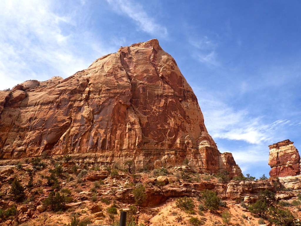
| Golden Throne | 2.0 mi (3.2 km) | 730 ft (223 m) | Strenuous | Views of Capitol Gorge and Golden Throne |
| Navajo Knobs | 4.7 mi (7.6 km) | 1,620 ft (494 m) | Strenuous | Continuation of Rim Overlook Trail, 360-degree mountaintop panorama |
| Old Wagon Trail Loop round trip | 3.8 mi (6.1 km) | 1,080 ft (329 m) | Strenuous | Pinyon-juniper forest, views of cliffs and Henry Mountains |
| Rim Overlook | 2.3 mi (3.6 km) | 1,110 ft (338 m) | Strenuous | Panoramas of Fruita and Waterpocket Fold from atop dramatic cliff |